


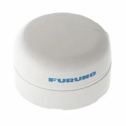
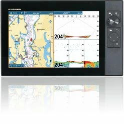
Furuno SC70 GPS Satellite Compass With Antenna
Original price was: $438.00.$94.99Current price is: $94.99.
- 100% Quality Satisfaction
- Nature-friendly materials, for a better planet.
- Shop with Confidence
- Worry-Free Shopping with Safe Payments


High precision and accurate heading
The Furuno SC70 GPS Satellite Compass is the
latest satellite compass, built on Furuno’s commercial-grade
technology platform. This satellite compass prove its value by
increasing the accuracy of other instruments, such as Radar, Target
Tracking (TT), ECDIS, AIS, Doppler Sonar and Autopilot. It provides
a highly accurate heading signal to these other technologies by
utilising the very latest GNSS (Global Navigation Satellite
System). It’s comprised of Galileo and GLONASS to ensure the
highest precision. The SC70 provides a variety of data, including
GPS Positioning, SOG (Speed Over Ground), COG (Course Over Ground),
ROT (Rate Of Turn) and 3-axis speed (bow, stern and longitudinal).
All of these data assist with critical manoeuvres, such as
berthing. The SC70 is maintenance-free and is a great asset for any
vessel.
Furuno SC70 GPS Satellite Compass Features:
- Provides highly accurate heading data for Autopilot, Radar,
ARPA, Scanning Sonar, Current Indicator, Chart Plotter, ECDIS and
Autopilot
0.4° (with SC-70) – Ideal for small to medium boats requiring
highly accurate heading - Utilises GNSS such as GPS, Galileo and GLONASS for high
precision
SBAS compatible (EGNOS,WAAS, MSAS)
Provide precise data for SOG, COG, ROT and L/L
Eliminating the problem of not having enough satellites at hand by
using multiple types of satellites - Speed on 3 axis (Bow, stern and longitudinal) for safe
navigating and berthing - Type-approved as THD, GPS and ROTI*. Complying with the IEC,
ISO requirements (For Solas Vessels)
IMO MSC.116(73) •IMO MSC.112(73) •IMO MSC.526(13) •IMO
A.694(17)
IMO MSC.97(73) •IMO MSC.191(79) •IMO MSC.302(87) •IEC 60945
Ed.4
IEC 62288 Ed.2 •IEC 61162-1 Ed. 4 •IEC 61162-2 Ed.1 •IEC 61162-450
Ed.1
IEC 61108-1 Ed.2 •ISO 22090-3 Ed.2 •ISO 20672 Ed.1
* requires the RD-50 as a display unit - Easily integrated into the existing shipboard network via
Ethernet - Rapid follow-up rate 40°/S
Twice the IMO high speed craft requirement, 20°/s - Maintenance free and no recurring cost as there are no
mechanical parts - Super short starting time – 90 seconds
Once the power is on, it takes about 90 seconds only to start
(The starting time will slightly differ depending on the equipment
location) - Precision Pitch/Roll data in Analog and Digital formats for
vessel stabilisation, SONAR, etc.
Furuno SC70 GPS Satellite Compass
Specifications:
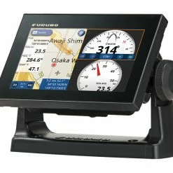
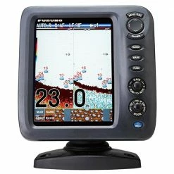
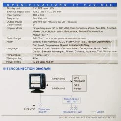
- Display: 4.3-inch colour LCD, 95.04 (W) x 87.12 mm (H) | 480 x
272 dots (WQVGA) - Heading Accuracy: 0.4
- Heading Resolution: 0.1°,0.01°,0.001° (select from
menu) - Follow-up: 40°/s
- Settling time: 90 s approx. (typical)
- Position Accuracy
GPS 10m approx. (2DRMS, HDOP<4)
DGPS 5m approx. (2DRMS, HDOP<4)
WAAS 3m approx. (2DRMS, HDOP<4)
MSAS 7m approx. (2DRMS, HDOP<4) - Interface
Number of ports (junction box)
IEC61162-2: 1 port (IN: 1,OUT: 1)
IEC61162-1: 8 ports (IN: 4,OUT: 8)
External beacon input (DATA5 port): RTCM SC-104 V2.3 (RS-485),
ITU-R M823
CANbus: 1 port
AD-10: 4 ports, for heading output
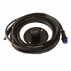
RS-485 : 1 port, for display unit connection
LAN (IEC61162-450) :Ethernet, 100Base-TX, RJ45 connecter - Temperature
Antenna Unit : -25°C to +55°C (storage: -25°C to +70°C)
Display Unit/ Junction Box : -15°C +55°C - Waterproofing
Antenna Unit : IP56
Display Unit : IP22 (IP35 : option)
Processor Unit : IP20 (IP22 : bulkhead mount) - Power Supply: 12-24 VDC: 2.1-1.1 A (included Antenna Unit and
Display Unit) - Weight
Display Unit : 0.7 kg
Junction Box : 2.9 kg
Antenna Unit (SC-703) : 2.8 kg
Be the first to review “Furuno SC70 GPS Satellite Compass With Antenna”
Related products

Reviews
There are no reviews yet.